 The
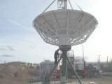
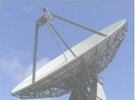
National Oceanic and Atmospheric Administration (NOAA) designated
full operational use of the 8.2MHz S-Band transponder
bandwidth of GOES-7 to PEACESAT in 1998. GOES-7 is maintained at
it current longitude position of -175° West +/- 3° by National
Aeronautics Space Administration (NASA) at the Kokee Park Geophysical
Observatory (KPGO) along with PEACESAT Headquarters. The
National Oceanic and Atmospheric Administration (NOAA) designated
full operational use of the 8.2MHz S-Band transponder
bandwidth of GOES-7 to PEACESAT in 1998. GOES-7 is maintained at
it current longitude position of -175° West +/- 3° by National
Aeronautics Space Administration (NASA) at the Kokee Park Geophysical
Observatory (KPGO) along with PEACESAT Headquarters.
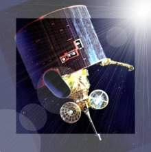
Previous to being designated to PEACESAT Operations, this U.S.
Weather Satellite acted as GOES-WEST taking observations in the
weather monitoring cataclysmic events such as typhoons and other
severe storms.
After the North/South Station Keeping capability & EPS Imaging
Telescope went faulty in the satellite, it was no longer suitable
for use by NOAA. PEACESAT on the other hand would still be able
to run its operations since these capabilities are not needed.
Prior to GOES-7, PEACESAT has used the following U.S. Government
Weather Satellite:
- GOES-2
- GOES-3
- ATS-3
- ATS-1
|